FFloods affecting much of the southeastern United States demonstrate the destructive power of rising sea levels and rising temperatures. Now, researchers at the nonprofit Climate Central are using artificial intelligence to predict how climate-related flooding will affect U.S. communities over the next 75 years if warming continues at its current pace. Predicting what will be given.
Previous studies have shown that sea levels along the U.S. coastline could rise up to 12 inches (30 cm) from 2020 levels by 2050. Storm surge flooding, which can occur even in sunny weather, is projected to triple by 2050, meaning so-called 100-year floods may soon become an annual occurrence in New England.
Ben Strauss, CEO and chief scientist at Climate Central, said the scale of the threat is difficult to grasp. He hopes the new AI images will help.
“We want to change the way flood risk is communicated in this country,” Strauss said. “When the photo is of a local place that you know well, that’s when the danger really becomes apparent.”
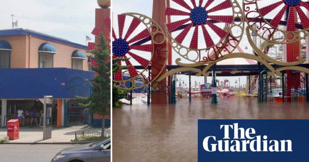
Climate Central sent trucks equipped with cameras along the East Coast and Gulf Coast to take images and video of flood-prone areas. Researchers say they can overlay images with elevation data to create real-time flood maps that provide a clearer picture of current and future flood risk.
“Some people use AI to create deepfakes, but we use AI in a very controlled way to explain scientific projects,” Strauss said. “When we take a photo, we analyze the location and altitude of every pixel in that image, forcing the AI to only pour water up to flood height.”
Climate Central shared images with the Guardian of iconic holiday destinations along the East Coast, such as Cape Cod and the Jersey coast, to visualize how they could be dramatically changed by rising sea levels and flooding.
Image shows water levels associated with a 100-year flood. It is so called because the probability of it occurring in 100 years is 1%. However, the frequency of these floods is increasing. Earlier this year, Maine experienced three once-in-a-century storms in three months.
According to the National Oceanic and Atmospheric Administration, melting ice sheets are the main cause of sea level rise, which has risen by 4 inches in the past 30 years alone.
“Rising sea levels will raise the launching pad for coastal flooding,” Strauss said. “So for every foot of sea level rise, a 3-foot flood turns into a 4-foot flood. And 3-foot floods are much more frequent than they used to be.”
The researchers used interim sea level rise projections from the Interagency Sea Level Task Force and predicted that the Northeast would rise 10 to 12 inches by 2050 and about 3 feet by 2100. “Part of the future of sea level rise is that the world’s ice sheets and glaciers will catch up with the amount of warming we’ve already caused, much of which is expected by 2050,” Strauss said. said. “Until 2100, we see a very big difference in whether we heat the planet further or stabilize it to something close to its current state.”
Researchers have found that one of the places most affected by rising sea levels is Cape Cod in Massachusetts.
“Every town on the Cape is focused on flooding being the biggest risk, and everything is at stake,” said Shannon Hulst, a floodplain specialist with Barnstable County on Cape Cod. “We are both influenced by the ocean, and the ocean drives our economy.”
An estimated 5.5 million people visit Cape Cod each year, contributing approximately $730 million to the local economy.
However, rising water levels are eroding the Cape’s famous beaches. “If we no longer have beaches to attract tourists, our economy will be very different,” Hulst said.
Low-lying coastal areas like Cape Cod are at risk from tides, waves, and storm surges.
Some have adapted by moving inland. Restore coastal ecosystems such as wetlands, beaches, dunes, and oyster beds. Raise buildings and roads. and the construction of sea walls. Residents have also raised foundations and built buildings on stilts to prevent flooding in their homes.
However, while higher elevation protects your property, it is not enough.
“Your home probably won’t be destroyed,” said Nick Angarone, New Jersey’s chief resilience officer. “But if you can’t get out to get food and water, or if the power goes out and you can’t get medical help or rescue teams can’t get there, can you really get back on your feet?”
Experts say some residents in flood-prone areas will eventually have little choice but to accept government buybacks for their homes.
Strauss said he hopes images like Climate Central’s will inspire people to think about local recovery plans and their own emergency preparedness.
“I believe that images showing the depth of floodwaters, even at the level of a hurricane, are far more powerful in persuading people to evacuate and save lives than all-caps emergency warning messages.” “We’re thinking about it,” Strauss said. “If they find out their house is going to be half submerged, that’s a different story.”


